Rivers are more than a beautiful blue ribbon of water threading its way across the landscape. Rivers move excess water out of the mountains to replenish the ocean. Rivers also help to move broken bits of rock – called sediments – out of the mountains to be deposited in various locations on the path to the ocean. The area over which a river drains is called a watershed and includes the main river and any tributaries that enter into it. Some watersheds, like that of the Mississippi River, are huge, while others are small.
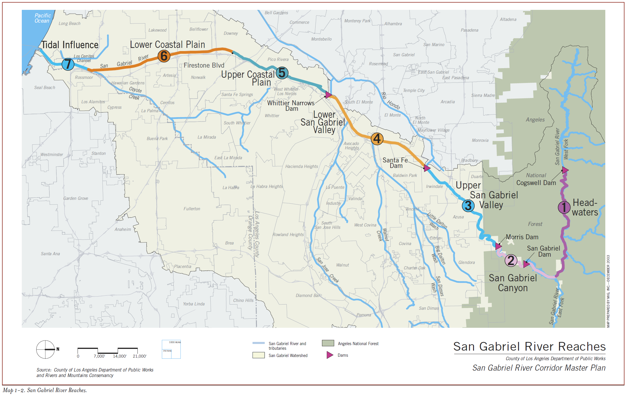
The San Gabriel River travels 59 miles on its journey south from the San Gabriel Mountains to the Pacific ocean. Its watershed drains 689 square miles, covering nearly the entire eastern edge of Los Angeles County (California Water Boards, N.D.). On this trip, we will follow the San Gabriel River from its headwaters in the San Gabriel Mountains, through the Upper San Gabriel Valley, and finish at the lower end of the Lower San Gabriel Valley, where it becomes channelized.
Map showing the extent of the San Gabriel River and its seven geographic regions. From SCCWRP Technical Report #499
To understand how rivers work, one must first understand the hydrologic cycle. This cycle is the ultimate recycling program.
Precipitation is water falling from the sky. However, water can be in the form of snow, rain, hail, freezing rain, fog . . . all of these are forms of precipitation. There are three possible paths precipitation can take once it falls from the clouds:
Infiltration: water gets absorbed into the ground. Infiltration capacity of the soil is controlled by:
Intensity and duration of rainfall
Soil saturation
Soil texture
Slope of the land
Nature of the vegetative cover
Transpiration: water gets transported through plants from the roots to the leaves.
Runoff: water runs over the ground’s surface and collects in low-lying areas.
The #1 function of rivers is to move runoff away from land and out to the sea (or lake). There are several factors that determine a river's velocity:
Gradient, or slope - The steeper the slope, the greater the velocity.
Channel characteristics
Shape - "V" shaped channels have less water and move faster, "U" shaped channels have more water and move more slowly.
Size - larger channels have more water that move slower.
Roughness - a rougher channel has more friction, which reduces velocity.
Discharge – volume of water flowing in the stream.
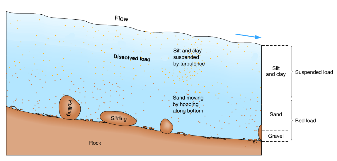
The second function of rivers is to transport sediments (see Sediment Diagenesis). The material moved by streams is the sediment load.
Sediments in the stream are classified by location. Stream bed sediments are a part of the bed load (aka alluvium), while sediments moving in the water are a part of the suspended load. The dissolved load contains ions dissolved in the water.
A river's sediment load is related to a stream’s
Competence - maximum particle size. The faster the water, the greater the competence.
Capacity - maximum load. The larger the river, the greater the capacity.
Discharge - the greater the discharge, the greater the competence and capacity.
A river begins as sheetflow (runoff). Sheetflow develops into tiny channels called rills, and will eventually flow into streams, rivers & lakes.
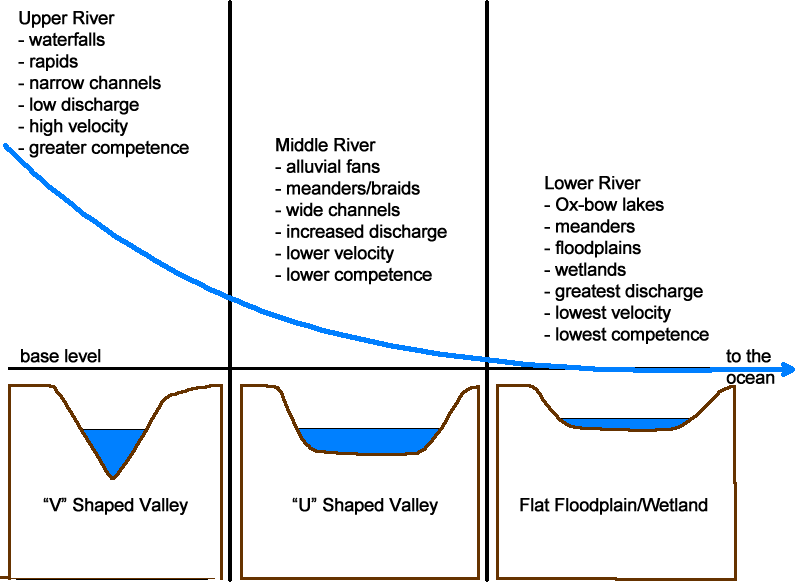
Water runs off the steep slopes in the mountains and into low-lying areas before it begins to head downstream. As it does so, the water cuts into the rocks to create “V” shaped valleys. The shape of the valley forms from two actions. The first is simply the erosive force of the water acting upon the rocks beneath them. The second has to do with elevation. Water will always try to maintain a flat, level surface. The water in the river high in the mountains is connected to the water in the ocean (aka base level). Thus, the water in the higher elevation will try to lower itself by down cutting through the rocks to reach the same elevation as the sea and produces the steep “V” shape of the mountain valleys as it does.
These mountain rivers are also called “upper valley” rivers. Upper valley rivers are typically smaller in width and the water moves more quickly through them. A smaller channel means a smaller discharge (volume of water flowing in the stream); the steeper slope of the channel means the water is moving at a higher velocity. The faster the water moves the more energy it has, and more energy means that the water can move larger particle sizes. This is called the river’s competence – the maximum particle size a river can move (e.g., a boulder vs. a sand grain). Sediment traveling in a river is called the river’s load. Competence is related to a stream’s capacity – the maximum amount of sediment (load) it can move. Thus, upper valley rivers, like those at stops 1 – 3, have “V” shaped valleys, have smaller channels, and the water moves at a higher velocity. Their riverbeds typically contain larger clasts (cobbles through boulders) while smaller grain sizes (clays through sands) are moved downstream.
As a river transition from mountains to flatlands, the stream velocity decreases. The decreased velocity means a decrease in the river’s competence – the river can no longer transport the larger grain sizes and the load (sediments) get deposited.
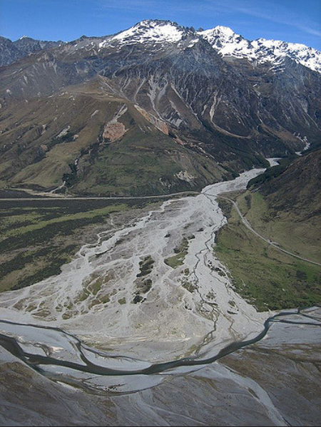
Features such as alluvial fans and braided streams form as a result of this slowdown of the river. Alluvial Fans develop as the now slower moving river loses competence and its sediment load is deposited. Braided Streams are another feature that typically develops in areas where sediment is abundant, water discharge is high and sporadic (i.e. seasonal), and vegetation is sparse. The braided pattern occurs due to large, rapid fluctuations in river discharge and deposition of large amounts of coarse sediment.
While it can be difficult to see today with the level of urbanization in Los Angeles, many of the “foothill” communities – Pasadena, Sierra Madre, Tujunga, etc. – were all built in part or entirely on the alluvial fans of the San Gabriel Mountains.
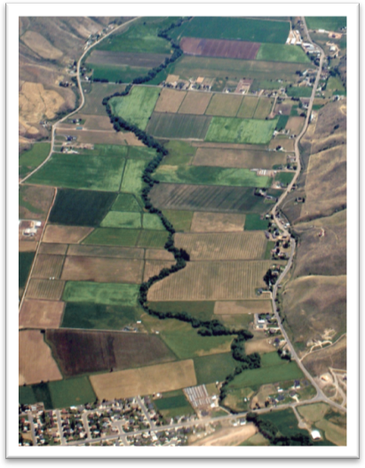
After exiting the foothills, the river transitions to flatter ground. During its journey out of the mountains, the river has had other tributaries join it. The river now has a much larger channel and discharge. However, since it is now traveling through terrain that is gently sloping towards the ocean, the river is now moving much slower. One method a river uses to slow itself down is meanders – curves in the river. The more curves there are the slower the water will flow. The now lower velocity means a lower energy level, and thus a decrease in competence. Now, only small grain sizes can be moved (clays and silts) downstream and the riverbeds typically contain sands and gravels.
Before, in the mountains, erosion was vertical – down cutting. Now, on the flat river plains, erosion is lateral – side-to-side. This forms a “U” shaped valley with features such as floodplains, meanders, yazoo tributaries, backswamps, and oxbow lakes. These last two features – backswamps and oxbow lakes – are types of freshwater wetlands.
Before the river enters the ocean it will flood the low lying coastal areas with water. Several types of coastal wetlands can form as a result - estuarine, freshwater, and seasonally flooded
Finally, after many miles, the river enters the ocean. The ocean is basically standing still compared to the river. The river slowly decreases its velocity, which then decreases its competence, and nearly all of the sediments carried in the river are quickly deposited. Two types of aquatic environments will form as a result: coastal wetlands and deltas. Coastal wetland areas are an important part of the river as they help slow down the water flow. This allows for the deposition of sediments before reaching the ocean. Any sediments not deposited in the coastal wetland areas will form a delta. The size and shape of the delta depends on a lot of factors, included the amount of sediment that is being deposited, the depth of the continental shelf, and whether the coastline is a submergent (lowering into the ocean) or emergent (rising up from the ocean).
Huntington Beach Wetlands. Photo by S. Leyva 2016
How the river changes from headlands to ocean . . .
Headlands
Foothills
Flatland
CHANNEL
Small
Medium
Large
DISCHARGE
Small
Medium
Large
VELOCITY
Fast
Moderate
Slow
ENERGY
High
Moderate
Low
COMPETENCE
Large
Medium
Small
•Smaller grain sizes moved downstream •Riverbeds typically contain large boulders
•Smaller grain sizes moved downstream •Riverbeds contain boulders to sands
•Smaller grain sizes moved downstream •Riverbeds contain sands & gravels
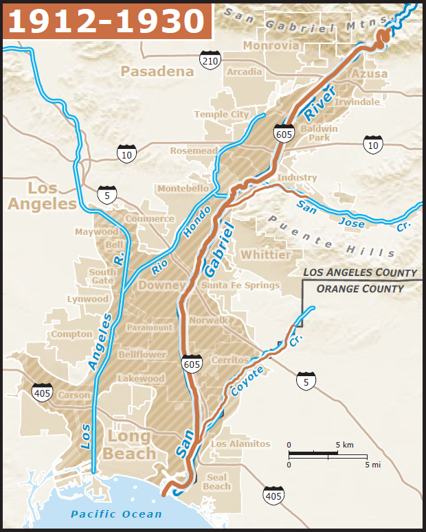
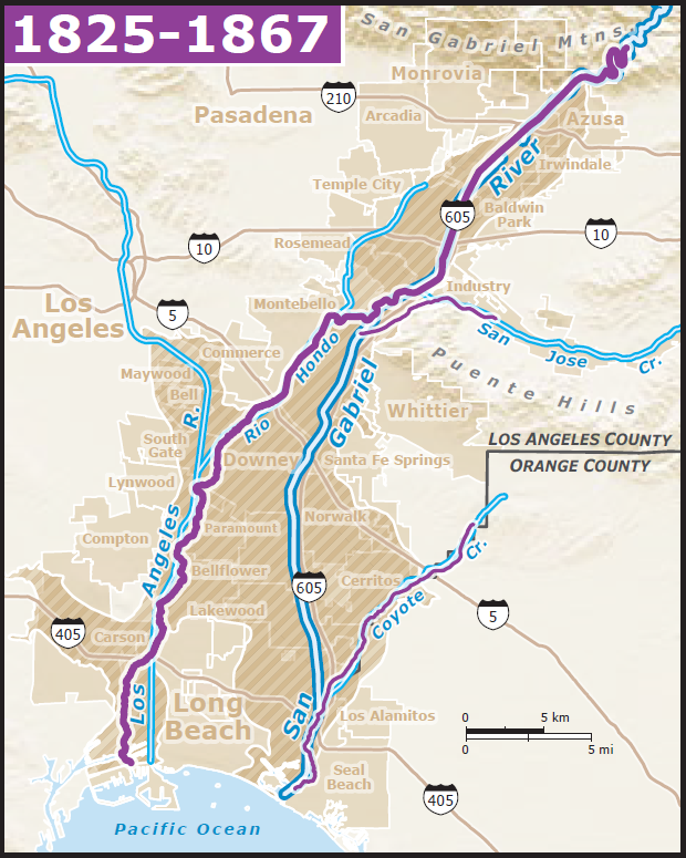
Historic San Gabriel River
Rivers don't stay put. Flooding increases the size of the river and its floodplain, sometimes causing it to form new channels or take over nearby streams. Changes to the landscape, such as the uplift of an area, can alter its course. Or, a river can dry up.
Between 1750 and 1905, the Southern California region received higher than normal rainfall amounts. The rivers in the area shifted around quite a bit as a result.
During this time, the San Gabriel River (purple) was a tributary of the Los Angeles River, the two meeting near what is now Downey.
(double blue lines represent the current river locations)
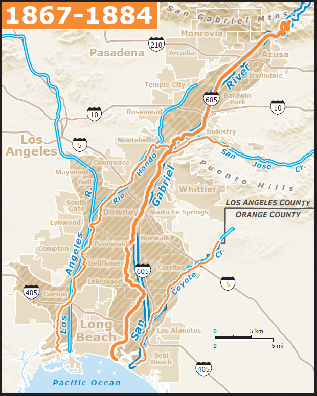
During the 1860s, a series of large floods changed the river's path. Now, the San Gabriel River (orange) followed close to its current path, with the Rio Hondo connecting it to the Los Angeles River.
(double blue lines represent the current river locations)
Increasing urbanization caused the river to change course yet again (green), cutting off from the Rio Hondo and merging with Coyote Creek in the coastal plain region.
(double blue lines represent the current river locations)
Another series of floods devastated the Southern California region in 1914, 1934, and 1938, thus leading to the channelization of most rivers in Los Angeles County.
(double blue lines represent the current river locations)
Images from SCCWRP Technical Report #499
The San Gabriel River has a fascinating history, one that is largely lost to us today. To learn more, check out:


.png)